A big thanks to Onx backcountry for making these post happen. Check out the Onx mapping app for your next backcountry adventure and click here to use the app to support your local avalanche forecasters

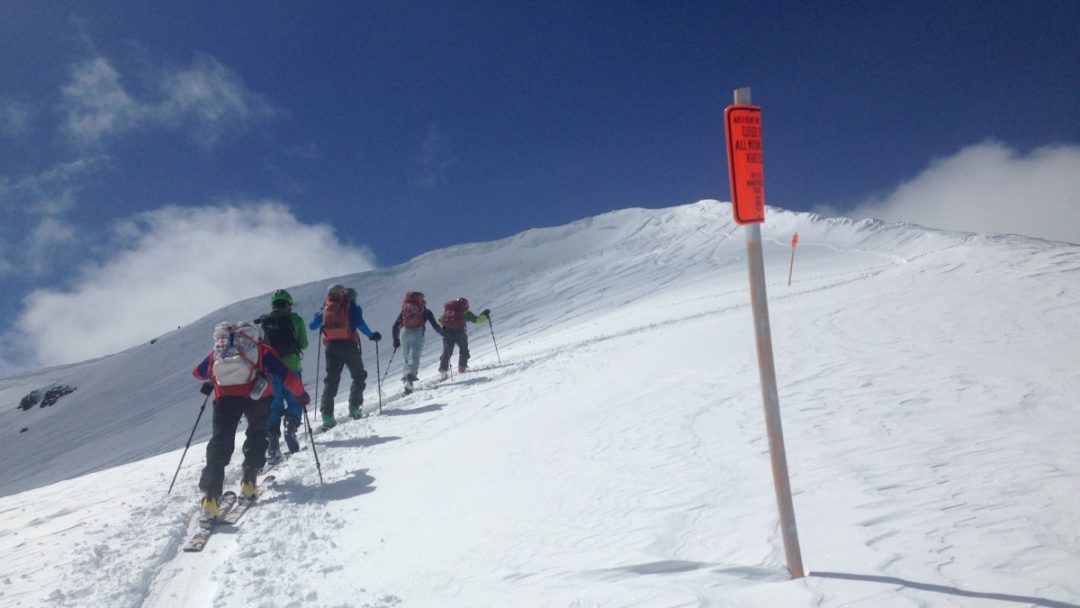
More than one person, or group, in a backcountry setting means communication can get complex.
You’ve headed into the backcountry with your core group of partners. The day’s avalanche forecast informs you. The communication is good; checking egos, you discuss skin track and descent options. After several thousand feet of climbing, you see a few fresh tracks snaking into a couloir at the drop-in point.
It appears some other group has a similar ski objective.
A basic thought experiment about how a common radio channel might benefit skiers in this situation has some essential upsides – first and foremost, knowing if a party is skinning adjacent terrain below or if you are about to ski on top of another group.
The idea of group to group communication in the backcountry is not new. Group to group communication, in this context, is communication between two discrete ski parties on a shared or known radio channel. After a season in Telluride, back in 2016, Matt Steen and Bruce Edgerly presented findings related to the use of a shared radio channel for skiers from different groups in the Bear Creek drainage. What Steen and Edgerly found was that intentional communication between groups could potentially reduce hazardous situations from arising.
“Introducing advanced communication through the use of radios, and specifically a common radio channel in high-use avalanche prone areas, is a way to aid in efficient avalanche prevention, safety and rescue. Use of radios increases the orderliness of communication among group members, between groups, and between groups and safety professionals in high-use backcountry terrain,” Steen and Edgerly concluded.
Last night, on the Northwest Avalanche Center’s virtual NSAW (Northwest Snow & Avalanche Workshop), Justin Davis, a member of SPART (Ski Patrol Rescue Team), a unit of King County Search and Rescue, presented information about a common radio channel initiative. The program encourages backcountry travelers to use a common radio channel in three distinct zones off Snoqualmie pass.
(Disclaimer: this is not an official NWAC program: “This program is NOT designed, managed, or monitored by the Northwest Avalanche Center forecasters and staff,” states the NWAC website.)

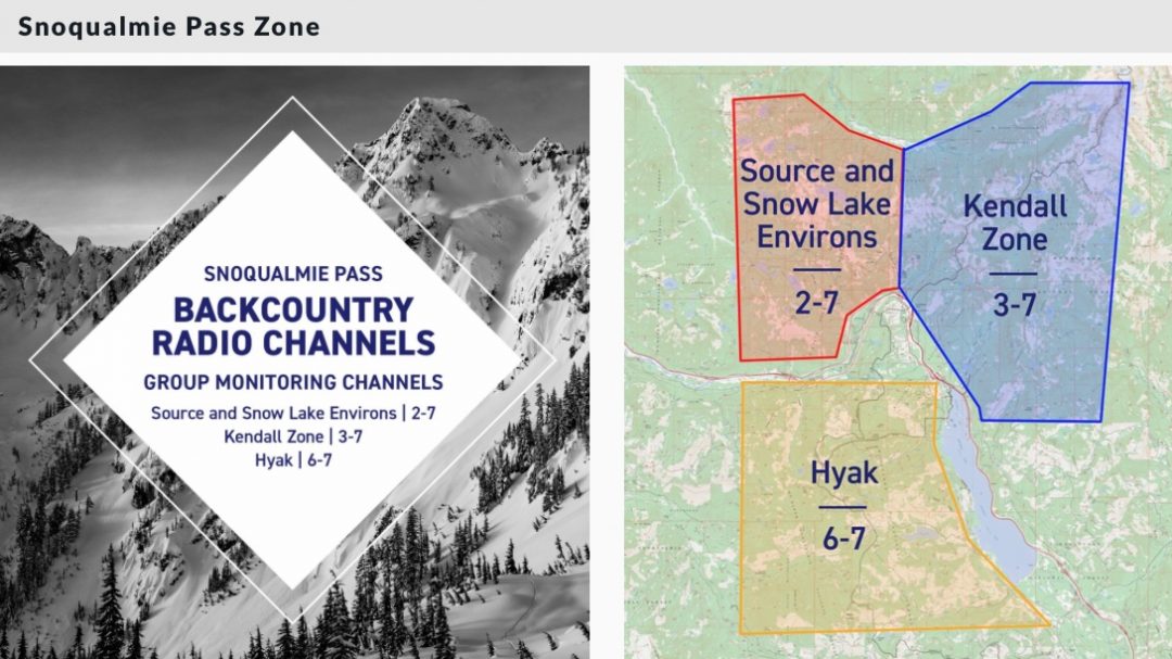
The Snoqualmie Pass Zone and related radio channels.
The gist of the program seems practical and straightforward. Users enter complex terrain, and when they enter that terrain, they know to switch their radios to a specific channel and code. (The three Snoqualamie zones each have a unique channel/code – see map above.)
A radio set to the appropriate channel/code allows a skier to monitor and communicate with other groups in that zone. During the presentation, Davis played audio from a day when several parties were skiing avalanche-prone terrain, and the inter-group communication was compelling. Users kept their discussions brief and precise, with essential information relayed like position and intent.
The program lays out the following uses and protocols:
Communication between multiple groups:
- When your group is about to enter complex terrain
- Information regarding potential hazards or critical snow & avalanche information
- When your group is clear of a given line or area, alerting other groups of a clear run-out zone
Other uses:
- Send a distress call for assistance in case of an accident
Request another group to call 911 or mount an organized rescue if 911 can’t be reached directly - Communication between partners as they travel in complex terrain (example, between zones of relative safety)
Regardless of the time and place, we know that agreed-upon norms for group to group communication are imperative. This small-scale project off Snoqualmie Pass might make us all safer out there.
Editor’s Note: Linked here is information about a similar program on the UAC website. This initiative involves the use of common radio channels in Little and Big Cottonwood Canyons and the Park City Ridgeline.
25 comments
I’d love to see Colorado start a similar program
Colorado (Telluride) is where this all started. Check out : https://www.telluridemountainclub.org/2016-2017-backcountry-radio-program/
Thanks for the nice write up and for highlighting this program. Great shout out to Steen and Edgerly! As mentioned in the presentation last night, we built this program to be both scalable and portable, and we created a playbook/recipe on how to roll out this program to other areas, as well as templates and tips and tricks, happy to share with anyone. bc_radio@kcspart.org
Thanks, Justin, I’d love to see that playbook. Please send!
Hey Edge,
The play back might be a ways out. We are planning on re-recording this via Zoom and will post on the kcspart.org website. Once this happens I will post something.
Excellent presentation last night, Justin. Thank you!
I really like this idea, but I want to reiterate the question I asked last night at NSAW: how to best describe your party’s position? The example from last night’s presentation works well…assuming that everyone is familiar with the informal names of various terrain features and ski lines. I’m familiar with some, but certainly not all, of the names in the Snoqualmie area, and I’ve heard certain areas referred to by multiple names, thus indicating that I’m not the only one who gets confused. While run names can be very precise, Justin’s comment to use more generic descriptions (e.g., NW slope of Snoqualmie Mountain at 5000 ft) seems like a better idea to me. Ideally descriptions would include names you can find on a topo map.
Another thing that would greatly improve the usefulness of FRS/GMRS radios would be a scan feature that lets you monitor multiple channels/privacy codes with a single radio. With a scan feature you can monitor the inter-group channel for your zone while also communicating on a private channel with the rest of your group. This feature is common on inexpensive VHF marine radios. RockyTalkie and BCA, you listening?
Regarding your comment about monitoring multiple channels… I think it’s called Dual Channel Watch if you’re shopping for radios.
Apparently the relatively cheap Midland GXT1000 has this feature. See this video
https://www.youtube.com/watch?v=RHBWEHoLTIk
I have these radios, but haven’t tried this feature yet. Will have to check it out.
Does anyone have experience with this in real life? I’m curious how you navigate the area channel versus group-specific channels. Stay on the area channels all the time and only use it when necessary? Scan functions on multiple channels? Only switch to the area channel when approaching complex terrain (that would kill many of the intended use cases like 911 relays)? I didn’t immediately see an answer in the links.
When I have friends with radios, we’ll often use them for short-range communication versus trying to yell, especially in the wind… (e.g., breaks, directions, gear issues). I tend to stick to one channel, so I’m not sure how those dynamics work when you want to monitor two instead.
That was my question too. The inner weight weenie in me cringes at the thought of carry two radios 😉
+1 to this question/comments. These zones in particular, which are very complex/micro and treed terrain, benefit from in-group radios just to “walk people down” on descents/exits, resulting in a lot of chatter, even if you’re super disciplined about keeping it short (SO easy to get out of sight, and there are tons of little navigation decisions that can mess you up). So, yeah, it sort of sounds like a two-channel solution (which is a PIA, IMO) where you’re on the zone channel on ascents or transitioning then a group one on descents maybe? I love this zone channel concept, just thinking through practical application when combined with how my groups tend to use radios. Curious what others think.
Greg, thanks for the kind words and the great question. Having done a small amount of inbounds patrolling, I know place names are critical to the ski area operation. As a guest or secondary patroller I was paired with a primary patroller local to the area largely because I had not passed their place names test and was not well versed on run and chairlift names. Additionally I know that confusion would occasionally crop up with old and new names for the same runs. Sort of like driving directions of “take a left where the big blue house used to be”.
Coming from a climbing background, where route names are often the only real landmarks I am inclined to suggest that the folks consult the guide books for place names whenever possible. Of course this is not without issues, as different guidebooks could have different run names, and guidebooks are notorious for going in and out of print/circulation.
Cool when discussion of radios brings up general communication issues, for example place naming. In my biased view, guidebooks perform a valuable public service in this regard, so thanks Justin. Of interest, there was a little squabble a while back when a backcountry cat skiing operator in Colorado blocked a guidebook author from publishing the run names they used for their cat business. The author ended up using a different set of names. Patently ridiculous — I could see no reason using the same run names held any harm to anyone — and if nothing else this weirdness was very unfriendly to local SAR volunteers, just imagine the confusion… in any case yeah, let’s name stuff, and keep it consistent, and use radios… Lou
The Utah Avalanche Center last year started a program to establish communication channels in certain ski popular zones. They used highway numbers to help people remember the channel. Here is the link to the article. I suggest that editors add this to the original posting so readers will see this information.
https://utahavalanchecenter.org/education/group-group-radio-channel-initiative
super idea ! Sailors use a common channel 16 for hailing each other and general monitoring then switch to another channel for conversing sharing distress calls, sharing information etc this is great !
As a newbie HAM operator from across the pond: how does the usual communication flow/protocol work now vs. how is this initiative gonna improve it? The links point to the BCA brochure, are people generally following that?
Hey Gin,
Have a look at the link (I posted above) to the Telluride site. They have some great info and suggestion on how best to communicate on the radio.
Cool idea! Photo not of Snoqualmie pass.
I outfitted our ski group with cheap GMRS radios (Retevis RB27). With a speaker mic and upgraded antenna they were less than $75 each and I sat with each family to make sure they got a GMRS license ($75 for 10 years for whole family, no test required). Now we can transmit on most FRS/GMRS channels at 5 watts (some channels are restricted to 0.5 watts for all radios). The radio has a dual monitor function so we can use our intra-group frequency for our own communication and chatter, but can monitor an area wide Group Monitoring Channel and switch to it as required to talk to other groups or rescue personnel. Now we have to work on setting up the Group Monitoring Channel protocol for our ski area – thanks for the roadmaps shown in this article!
I’ve gotten on the same channel as other groups at the top a few times – just by chance when 2-3 groups converged, talked, realized all were on radios and sync’d up. Was quite helpful on occasions where terrain really funnels further down (and out of sight), and you want to clear lines below before dropping in.
If someone sets the zones and channels (and maintained a master in say a google sheet), then folks like wildsnow, caic, etc could link to it. Would also be helpful to also define the zone via a GIS shape file that could be downloaded into gaia or similar, and named by the area x channel (like in the Snoq pic above, but linked and downloadable). I can’t imagine there’d be any liability – but who knows these days? It would take some time to spread the word and get uptake, but radios are only increasing in use.
Could WS please update their radio reviews? The current article is very old. Most of the models referenced are no longer made and it’s hard to map the old ones to the new.
We have some Rocky Talkie radios coming in for a review. I’ll look into a BCA Link 2.0. Feel free to suggest other radios you would like to see reviewed.
Rocky Talkie and BCA Link 2.0 are obviously top two in the ski community.
The best Motorola radios would be good to add… they’re so common.
I’d also like comparison to the Midland GXT1000 which apparently have a Dual Channel Watch feature. (see my comment above).
No one mentions the problem of a group or solo skier in the area without radios of the sort you are discussing. The radio active users may think things are clear when they are not, and we are back where we started.
While I’m particularly interested in this issue, when traveling solo in these areas (Snoqualmie Pass is essentially home for me as a skier), I’ll have my radio on and listening for traffic on the public channel. Awareness of the locations of other parties is especially important for a soloist, for whom there is no margin for error.
It is really great to see this work continuing to both gain attention and resonate — figuring out how to coordinate in high-usage terrain is a timely issue that may only grow in importance. A big thank you to SPART and all of the other groups working to find a way forward here.
It is my impression that the coming half-decade or more will see the backcountry community sort through this issue in detail.
As we look toward solutions, which I’ve written on in the past, radios are going to be a key element, but far from the only one. As we figure out our community protocols, I encourage people to consider:
1) Radios with the capability to monitor two channels, and easily transmit on a desired channel, without confusion, will become key. Aviation and marine radios do this (look up “GUARD” for aircraft). We will need to do so, too.
2) How will we preserve the wilderness experience? Many of us go to the mountains explicitly to escape the complexity of civilization.
3) The protocols we use must be easy to learn and understand, and must be robust-enough to function safely (or at least fail gracefully) when utilized by inexperienced and boundary-pushing adolescents. We were all there once.
Comments are closed.