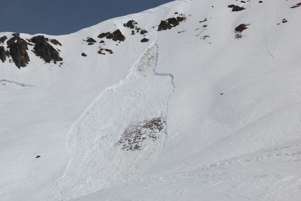
Notice how a loose-wet or point-release avalanche starts off the rocks, then triggers a slab below. Dark-colored rocks absorb sunlight, warming the snow around them. Bonds loosen within the snow, creating a small, loose-wet avalanche. The dense debris rolls downhill and then triggers a slab avalanche on steep, rocky, shallow terrain.
Phew, we made it. Between COVID and pissed-off weak layers from Bishop to Bozeman and Bellingham to Berthoud, that was a messed up winter. I spent much of it in France, where the ski lifts never opened. I did get to climb some fantastic ice and ski-tour on relatively empty peaks, but nonetheless, seems like we all had tricky conditions — snowpack and otherwise — to navigate this winter.
And here we are, springtime. Time to turn off the avalanche brains, crack out the skinny skis, and let ‘er rip, eh!?
Not so fast, bruddas and sisters! Spring skimo season has indeed arrived, but that doesn’t mean we’re on cruise control. We’ve just traded one set of problems for another. Let’s identify some of those and dive in to solutions for them.
Wet Avalanche Types
The most obvious hazard to keep tabs on are the “wet” avalanche types — wet loose, wet slab, glide cracks, and let’s throw cornices in there, too. Somebody has already balked and muttered, “That’s a storm problem!” I’m with you, much of the year it’s a storm problem, but as you finally show those sinewy, ass-white legs to the sun, it’s time to put cornices on our list of problems, too.
Intense solar input, longer days, higher average temperatures, and the party crasher of all ski trips — rain — all conspire to increase the avalanche danger via wet avy types. We’ll start to see these types listed on the avalanche bulletin, so a couple thoughts.
Glide cracks Unpredictable, don’t necessarily respond to explosive control, sometimes sit there for months, sometimes they appear and fail that same day. Point is, it’s the whole snowpack starting to move and if you’re involved, the odds are stacked against survival. Avoid at all costs.
They often form on grassy slopes or slabby, rocky areas, often first at lower elevations on sunnier slopes, then climb higher as spring progresses. Make a note of where you’re seeing them, focusing on aspect and elevation. Share your obs! And did I mention, don’t be on slopes with glide cracks, don’t be under slopes with glide cracks. Period!
Wet slabs Another unpredictable, tricky type. Patrollers throw bombs on ‘em, a hundred skiers might ski across them, they might go several days without a refreeze and then BAM, huge, wet slab … and again, odds are stacked against you. These can be large and destructive, they’re usually heavy and dense, they often initiate and travel on slopes under 30 degrees, and they can travel farther into runouts than we think.
We often endure a “wet slab cycle,” or the “spring shed,” with these. Especially if we have dormant persistent weak layers in our snowpack, these can reawaken with a warming snowpack and we’re right back to spooky conditions, caught skiers, and unfortunately potential fatalities. Heads up. The forecasters will be warning about these when the time comes and listen up — these are the meth-head cousins of the deep-slab avalanches from last winter, and they’ve just showed up on your door step, hoping to crash for a few days. Best clear out and just let ‘em get it out of the system before you come back.
Loose wet Phew, now we’re getting into more predictable, less destructive avalanches. This is merely your annoying cousin from Poughkeepsie, not the aforementioned meth-heads. Loose wet avalanches plague Coloradans any time there’s snow on the ground, given the amount of intense sunshine that state receives. Most other places, though, if you have warming temps, bright sun, and/or rain, start looking out for these. Usually, there are obvious signs (roller balls, point releases) and they’re easy to avoid (more on this in a sec).
If it’s warm enough to worry about springtime problems, then let’s consider sagging cornices, too. Late winter, early spring, these things have been growing all season, so the danger is two-fold: if a cornice collapses, it could easily be school-bus-sized chunks and more destructive power. Even if we manage to dodge huge blocks of cornice, it could trigger a deeper, larger, deadlier avalanche!
Avoidance
Happily for us puny, fragile humans, we can pretty easily avoid these problems. With glide cracks, wet slabs, and cornices, re-summon your finely honed discipline. You spent the winter avoiding persistent problems by staying off of terrain forecast for these problems. Now you can do it again. Avoidance is the best strategy for these trickier, less predictable types. Don’t be sunbathing below terrain cursed by these problems, either. Come on, you can do it!
For loose wet avalanches, the main strategy is start early, end early. This is a simple heuristic for managing them, but we can go a bit deeper. First off, do your homework — what’s the forecast say? Daytime warming? Will it warm up right away, or will there be morning cloud/fog and you might have a longer window?
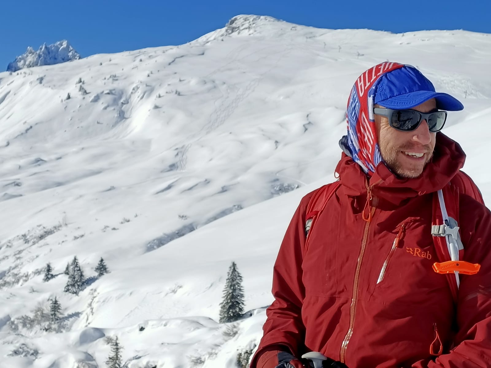
The author on a late-winter tour above Chamonix, France. The day went from bitter cold to spring-like warmth within hours.
Springtime signs of unstable snow eventually change from shooting cracks and whumpfing to “pinwheels” and “rollerballs,” moistening snow surface, and deepening “boot pen.”
You know the pinwheels; these are the bits of snow that come off rocks and cliffs, then roll downhill, entraining more snow as they go. Keep an eye on the snow surface, too. If you can reach down and easily scrunch snow into a good snowball, it’s moistening. If you can squeeze liquid water out of the snow, it’s becoming saturated and surface layers are losing cohesion/stability. Finally, if you can step out of your skis or board and step into the snow past your ankle, the surface snow has lost too much of its cohesion: time to be off sunny aspects!
Relief matters
We’re not talking about antacids here, people, we’re talking elevation. I hope you live in a place with thousands of feet of elevation to climb up and ski down, but I shall now dispense sage-like advice, so take notes, friends: every blessing in your life comes with a curse.
I have no idea if this is true, but it kinda makes me sound wise, so I’m putting it in here. Whatever the case, keep in mind that your epic, five-thousand-foot run means perfect snow at the top will probably be hot mank by valley bottom. Timing becomes critically important on a ski run with significant relief. Often, that means leaving a summit when the snow surface might still be frozen from the night before. Fall hazard might be worse in these conditions, but you may need to accept that hazard to avoid skiing in knee-deep slush at the bottom of a long couloir.
Recognize this challenge and also that riding in a confined couloir, with rock walls, can mean a more rapid warm-up. Now the lower third of your couloir might be double-baked in the heat. Don’t get surprised and have no escape!
Sunhit!
The Caltopo Jedi amongst you have already figured out that the web-based app will give you a pretty darn-good estimate of when the sun will hit a piece of terrain. This is critical in timing your objective. For skiing something really steep, you want some edge-penetration, but not so much surface loosening or melting that you’re flirting with avalanche hazard. An hour of sunlight might be perfect, while two hours might make conditions far more dangerous.
Use Caltopo, guidebooks, or a local buddy’s knowledge to make sure you are on top at the right time — and if you’re unsure, it’s better to be up there an hour early than an hour late. Expert planning and prep will keep you safer.
AMGA-certified ski guide, Donny Roth, relaxed and soloing the north face of Longs Peak, before showing the boys how it’s done on the down. The skies clouded over minutes after this photo, refreezing the snow surface almost instantly. At over 14,000 feet, what was becoming “hero snow” became scratchy ice above huge cliffs. Donny was pretty relaxed. Me? Ice ax, puckered, not relaxed!
Aspect and Relief
Expert planners build a tour that chases the softening snow throughout the day, starting on a NE/E aspect, wrapping around to S, before finishing on a west aspect — the sun warms the snow as you ride and you’re off a sun-baked aspect before it’s sketchy.
Often, in early spring, you can find corn on sunny, lower-elevation aspects, and at the same time, winter conditions on higher, north-facing aspects. Now we are really putting our skills to use! Plan a great tour like this and you’ll get both seasons in the same day, but just keep in mind, you might encounter the full buffet of avalanche types throughout your day. This requires panoramic awareness and a crack team to manage changing conditions, share observations, and reevaluate as you travel.
Overnight freeze and crusts
For all this Jedi planning, you probably know to keep an eye on overnight freeze. In data-rich places like Colorado, where we can check SNOTEL sites for real-time data as well as overnight history, it’s easy to see how long it froze and at what approximate elevation. Great, do it!
Remember, though, that a clear nighttime sky greatly increases radiative re-cooling, meaning the snowpack radiates long-wave radiation at night, back into the sky. A layer of cloud, fog, or forest canopy, and the snowpack ends up insulated and won’t radiate this energy, which means a mushier surface come morning. Conversely, if the sky was clear, then chances are your upper centimeters of the snowpack froze hard.
Point being, for spring skiing, we need freezing nights so there’s a supportable crust atop the snowpack, as well as a refrozen deeper snowpack. The crust allows us to travel easily and quickly in the morning, while the refrozen snowpack remains more stable and less likely to avalanche.
Several nights of above-freezing temps and you should assume the overall snowpack is losing strength and your mindset should shift to a more defensive one. Heads up.
If you happen to live or tour in a data-poor environment, then you can do some quick investigative work. Step out of the car and see if puddles in the parking are frozen solid, barely frozen, or still liquid water. Once you start touring, do a hand pit and see how thick the surface crust is. Do this every several hundred feet of elevation gain. A one-centimeter crust and it didn’t freeze much overnight. A nice, stout six centimeters of frozen snow and you might have a few hours to slide around. Dig deeper, too —- is the snow moist (you can make a snowball, but don’t see liquid water) 60cm down or is it truly wet (you can wring water out of it when you make a snowball)?
After you start touring, keep a keen eye on how the sun is affecting the snowpack. Step out of your skis and see how deeply your boot penetrates (boot pen) into the snowpack. Above the ankle and your day is done on that aspect, at that elevation. Remember, those wet slabs and loose-wet avalanches can get going on 25-degree slopes. Dial it back!
Dormant layers
Recall those layers from January and February, the ones that killed members of our community in Washington, Utah, Colorado, and beyond? The spring warm-up can reawaken those layers, if they’re still present.
Here’s where we rely on the expert forecasters and guides in our locations. Your local avalanche center will be watching these layers closely and have probably been tracking them all winter. Inshallah, these layers have bonded to those around them and perhaps those ill-natured facets have sintered to the surrounding — but if they haven’t, they could become a problem, again.
How? As our snowpack begins to melt at the surface, that liquid water drains through the snowpack. Eventually small channels will form and the snowpack will drain into the ground below. If, though, there’s still a crust 120cm down, free water can drain through the snow and then pool on top of the crust. This pooled water loosens the bond above the crust and suddenly you have 120cm of saturated snow unattached to a melt-freeze crust — and you know what happens next.
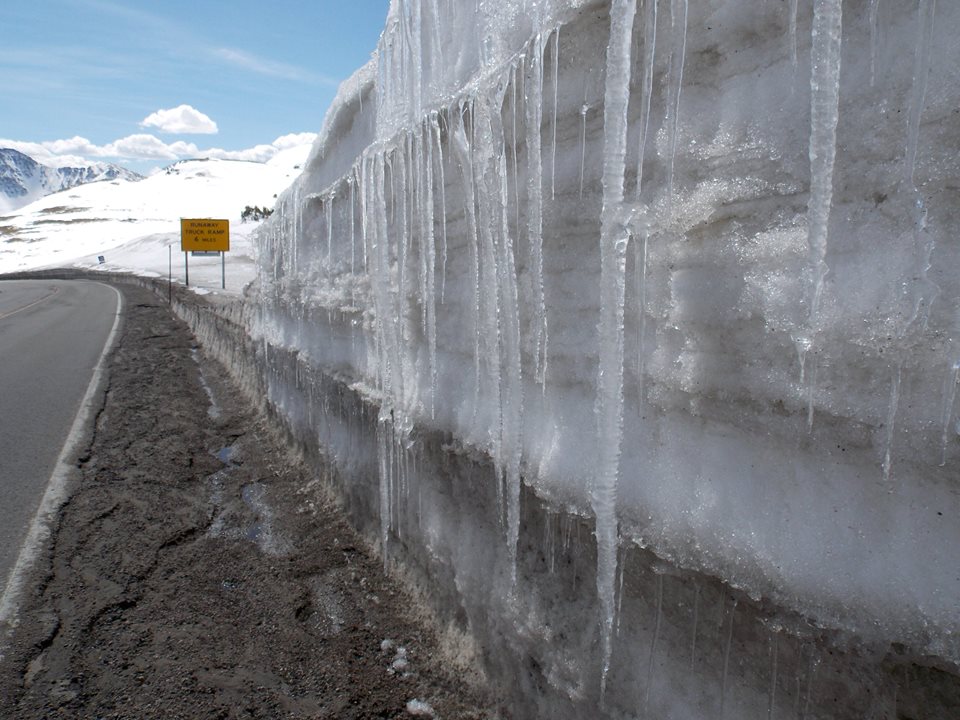
This road cut on Loveland Pass illustrates water draining through the snowpack until it hits a crust. South-facing terrain gets baked in the Colorado sun, creating melt-freeze crusts throughout the snowpack. Notice how the icicles form – this is how water drains through the snowpack, but in this case having the road cut allows it to pool and then flow towards the road, giving us a great glimpse of how drainage works come springtime. At night, the refreeze occurs and we see icicles at each layer.
Luckily for us, forecasters can see this coming and will be warning us about it. You’re good to go, but only if you muster the discipline to absorb their message and travel accordingly. Avoid the terrain they’re warning about!
Voodoo
A quick word on voodoo, dark arts, and internet bullshittery. There are some who regularly check stream flows to gauge runoff in the spring, and then use these data to try and predict avalanche hazard or an avalanche cycle. This is an extremely tricky business and highly nuanced. Leave that to the experts and avoid getting suckered into trying to divine much meaning from stream flows and the like. Heads up for the dude (is it always a dude?!) holding court on Facecramp about cubic-feet-per-second in Clueless Creek and what’s going to happen three days from now!
Snowpack Tests
As I said above, wet slabs and glide cracks often don’t respond to explosive control, so likewise, your regular arsenal of snowpack tests might be less instructive, too. Cutting cornices onto a slope, while good for getting more Insta followers, isn’t as reliable a snowpack test as one would think, especially for deeper instabilities and/or glide cracks.
Short of monitoring shallower layers in the upper snowpack, snowpack tests are tricky in the spring. Trying to test deeper layers that have been dormant requires knowledge of which tests to use and why, as well as an expert read of weather phenomena. We need to ask ourselves if we possess these skills.
Hazard Matrix
Wow, I’ve been blathering for quite a while now, so one last point and then you can hit the “comment” button and tell me to stop being such a long-winded moaner.
In the spring, we often slide into terrain we wouldn’t touch in the winter. Good on ya, probably a smart call! Keep in mind, though, as we begin to flirt with steeper and “radder” terrain, we’re adjusting our matrix of risks. Instead of avalanches, we’re now playing with you-fall-you-die riding, perhaps. We might have spikes strapped to our feet and pointy stuff in our hands on the up. We’re doing a slightly different sport, truth be told.
Just take this as a friendly reminder that firm snow, steep terrain, and sharp objects can conspire to injure or kill us just as easily as a deep-slab in winter. Make sure you’re adjusting your perception to the differing risks of spring skimo missions.
Off the soapbox.
Enjoy
Bluebird skiing, the occasional storm, more stable snow — hot damn, it’s spring! Enjoy the heck out of it and keep in touch. This is my favorite time of year, rock climbing and mountain biking down low, great skiing up high, and long days to fit it all in.
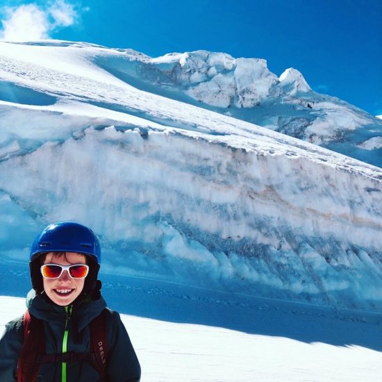
Luca Coppolillo enjoying spring skiing on the glacier above Zermatt, Switzerland. Soft snow, bright sun, big smile – oh yeah!
Rob Coppolillo lives, writes, and guides from his home base in Chamonix, France. He grew up in Colorado, finished school at CU-Boulder, and has a side hustle as a freelance writer. He’s the author of The Ski Guide Manual.
Rob Coppolillo is a mountain guide and writer, based on Vashon Island, in Puget Sound. He’s the author of The Ski Guide Manual.