During my January travels in Europe, I returned to Austria from Switzerland feeling strong and ready to tour. Much of western Austria was a bit light on snow, but my friend Fritz looked at the reports and figured the region south of Innsbruck (near Italian border) had enough white stuff to be fun. Schoberspitz is another rocky alp, moderately high at 2,602 meters. It’s not quite as heavily traveled as some of the other areas I’ve been in, but as much of this terrain does, it still gets tracked up fast.

Your friendly blogger on the Schoberspitz
Indeed, the number of people who ski tour in these areas of Austria continues to amaze me. The sport is simply huge. Even simple up-skiing at resorts has gotten big. For example, at one resort just east of Innsbruck it’s said they get more people on skins than buying lift tickets. That was a problem for the ski lift operator but the restaurant loves it as the up-skiers eat even more than the lift skiers. Luckily these areas of the Alps have a vast variety of access so the use gets spread out. If we had these levels of use here in Colorado, we’d have big problems because we have so little access in comparison. At any rate, the day was bluebird I’m pleased at how mine and Fritz’s photos turned out. Enjoy.

The closest restaurant to the trailhead is always an important component of the plan. Gasthaus Olpererblick and Schoberspitz above on left. The huge peak to right dominates views around this area, forgot the name, but over the hill is the ski resort where Fritz and his father tested the first pre-production skiable Dynafit binding (then known as Low-Tech).

Maria came along on this trip. She's a long-time friend of Fritz's family who's always game for a ski tour. She had some knee problems during this trip but it sounds like she's getting that taken care of. We wish Maria well in her healing!

On the up, looking southwest.
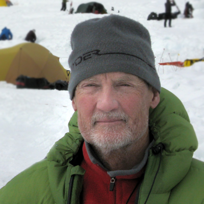
Me at the summit.

Ride those Manaslus Lou!

Looking down at Toldern and gasthaus.

Riki hits a light patch in the trees. Some of the timber skiing was good as well, but we did get into some tight bushwhacking that was uncharacteristic of the usually civilized skiing I've gotten used to in this area. No problem with that, not like I haven't bushwhacked before.

Obligatory kuchen at Gasthaus Olpererblick. Last year I had a gigantic schnitzel here, but that was after about 1,000 more vertical feet. One extra pastry a day seems to work for me, but giant schnitzel as an afternoon snack might no be sustainable.
17 comments
Hey Lou,
In that picture of Maria, are those avalanche control structures on the ridge behind her?
Ed, yeah, some HUGE slides drop about 1,000 meters from there. The easterly (left) end of that ridge is the Sumpfkopf 2341 meters.
Hey Lou,
the peaks in your first picture are the Olperer (in the middle) and the Sagwand to the right.
Cheers, Robert
Thanks Robert! I thought I’d remember Olperer after being there a couple of years in a row, but I guess I didn’t take my ginko. It’s a beautiful mountain.
“If we had these levels of use here in Colorado, we’d have big problems because we have so little access in comparison” It seems that backcountry skiing is widespread like never before here in WA, as is off-road snowmobile riding. Stashes are fewer and mostly tracked now. Here in NCW, the Wenatchee Mountains have more ski tracks and more snowmobile tracks than I have seen previously. This was enhanced recently by several weeks of stable powder snow conditions. It seems that improved technology, both in randonnee ski gear and also in snowmobiles has resulted in steep and formerly distant open backcountry slopes now tracked in a routine fashion. Numbers of snowmobile access-ski tourers have increased, that being the most effective way to increase access to backcountry skiing here.
There is a valley of fond memory that I skied 45 days from a camp throughout the winter of 1990 that then saw only my ski track, and no snowmobiles; That distant from a Highway valley now is a busy snowmobile playground, and on the list of several of us to ski from our snowmachines. Fortunately we can ride to the Alpine Lakes Wilderness Boundary and drop in. there it is mostly untracked since there are only a few snowmobile tracks in the Wilderness (the presence of snomo tracks in a steep bowl was helpful for stability evaluation, however).
Yeah, rando, the numbers will probably continue to grow, but I predict they won’t grow as fast or as much as one would think. I say that just because of U.S. demographics. On the other hand, compared to EU very few North American skiers do ski touring. So as more resort skiers learn the joy of uphilling, that’ll support continued growth. The biggest problem, in my view, is that huge tracts of our mountains are relatively inaccessible. To preservationists that’s not a “problem” but rather a solution. But my feeling is we could have more access and still practice effective conservation.
I think that the growth will depend on the image the AT adopts. Kayaking and windsurfing went through their popularity bubbles because they projected an “extreme” image, to the point that it seemed like only daredevils could enjoy these sports.
I am happy to hear that backcountry skiing in Europe is viewed as an alternative to lifts and is growing in popularity.
When backcoutry use grows in our side of the pond, we will have a big constituency to advocate for the “access with conservation” approach that Lou mentioned.
Hey Lou,
one correction: the peak to right of Olperer is the famous Schrammacher (Sagwand is right to the Schrammacher but not on the picture anymore). Very nice climb at the ridge in the summer and a nice tour for skiers from Southern Tirol.
Greetings from Munich
Sorry Urs,
but were both wrong. I mentioned the names from memory and didn’t check them on the map. But since I have a similar picture with the Olperer and the next peak and was also a few times on the Schrammacher, I was sure it could not be the Schrammacher. I checked the map and as I wrote above we were both wrong. The peak to the right of Olperer is the Fußstein.
Greetings from South Tyrol
Robert
Nice peak tour. Skiing a peak is always a great experience.
I’ll slip this in here, even though it doesn’t really contribute to this discussion. I’m one of the growing numbers of new AT skiers in Alaska and I’m in need of some advice regarding the fit of AT boots vs. the race-fit Langes I’ve been skiing for the last 15+ years. I’ve been to two different boot fitters who both tell me the shell is the right size for my foot, we’ve tweaked it in several ways, including custom footbeds, and it has helped, but I still can’t get the performance I’m used to without cranking the boot so tight that it kills me. I’m skiing a Garmont Adrenalin, which I’m very happy with while skinning and hiking (with the buckles loosened, of course) but when it comes time to make turns, I feel like I have little control without cranking them down. I have been advised that it might be my technique needs tweaking now, which sounds logical, but I’m looking for a second opinion. Have my Langes allowed me to get lazy? Is it just a matter of getting used to not being as closely connected to my skis? My feet don’t slide around in the boot, but I do find myself “crabbing” with my toes while skiing.
Thanks for any advice you’d care to give.
Hi Lou,
Here is an interesting web site for hiking in Switzerland.
http://www.sac-cas.ch/index.php?id=416&L=3
You can plan longer trips and find hut to stay overnight. There are also excellent maps and downloadable GPS tracks for ski trips.
Map example.
http://www.gps-tracks.com/TrackToGoogleSatMap.asp?TrackId=S00014&LangDialog=e&LangTour=e&MapMst=5&Random=39499&Filter=&CssFile=http://www.sac-cas.ch/extern/tis.css&FiOrt=Alpenonline&WHeight=768&WWidth=1024
You can also pan the map and get into France and western part of Austria
Sorry, the above map doesn´t work so here is another one.
http://www.gps-tracks.com/TrackToGoogleSatMap.asp?TrackId=H00007&LangDialog=e&LangTour=e&Random=96313&Filter=&CssFile=http://www.sac-cas.ch/extern/tis.css&FiOrt=Alpenonline&WHeight=768&WWidth=1024
Map links doesn’t work from your site for some reason. You have to find them from the http://www.sac-cas.ch/index.php?id=416&L=3 site.
Pick a hut and go for ski trips and then the XXL map.
Mat, I’m not sure what you mean about my maps not working. They’re just basic embedded Google maps, they should work for nearly anyone. But they don’t have the routes on them so they could be better whether they show or not. I’ll look into it.
Lou, your map is fine but not very detailed. It´s the long link that I pasted that should show a map. It doesn´t work when pasted into your blog.
Anyhow, if you go to the http://www.sac-cas.ch site you can find very detailed maps there along with many routes to climb.
Thanks for sharing your experience, looks like a wonderful place to ski.
Comments are closed.