A big thanks to Onx backcountry for making these post happen. Check out the Onx mapping app for your next backcountry adventure and click here to use the app to support your local avalanche forecasters
It was a toss up between this presentation by Diana Saly being the coolest thing at ISSW, or Sarah Carpenter and Emmery Rheam’s presentations on teenage avy education.
The embedded video above is unfortunately a truncated version of what Diana is working with (and has been published elsewhere on the web for some time). In her full version presented at ISSW, she has numerous skier routes traced by lines as the time lapse follows them. Moreover, she does a more extensive job of showing the skiers working around the avalanche, both before and after the fact. (Once this proceeding is published on ISSW site, I’ll link.)
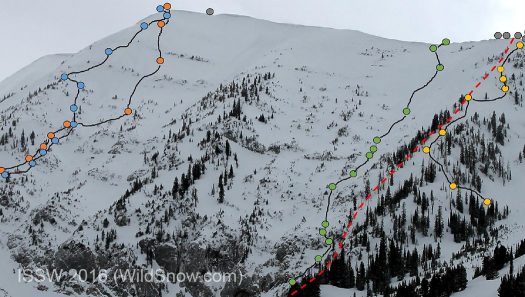
Still from Diana’s presentation, her caption: The first four skier tracks of S1 (green) S2 (blue) S3 (red) and S4 (yellow). S1 and S2 act as a group, S3 and S4 ski the slope simultaneously following very different lines.
What stood out to me is how “sidecountry” skiing is so dependent on that nearby ski resort boundary. Evidenced by once the skiers noted the avalanche, their convenient “stage left” exit back to the safety of controlled slopes and perhaps a warm cup of cocoa at the base lodge.
They do say that when planning your ski routes, have an exit plan. Only in North American ski touring I usually assume that’s moderate backcountry terrain — rather than a nearby resort! But whatever works.
In a broader sense, what’s interesting about this sort of thing is how avalanche researchers are focusing ever more on human behavior. Remember the days when “avalanche study” meant nothing more than snow science, with perhaps a short tale or two about how “the victim, at 18:00 hours, was entrained?”
Clearly no more. Counting all the oral presentations at ISSW, about 28 out of 70 presentations could said to have covered some aspect of human factors. That’s significant. It means the safety of recreation in avalanche terrain is on the radar more than ever. Yet more, it means ISSW is becoming more of something the non-scientist backcountry skier might find worth the money, time and travel to attend. (ISSW 2017 will be in Innsbruck, Austria.)
As for Diane and her time lapse camera, here’s hoping she’s running it this winter as well and will present a sequel. I’ll propose a more catchy title: “Bridger Bowl Football Skiing, End Zone or the Sidelines?”
Condensed version of her abstract intro:
USING TIME-LAPSE PHOTOGRAPHY TO MONITOR AVALANCHE TERRAIN
Diana Saly, Jordy Hendrikx, Jerry Johnson, Doug Richmond, Montana State University and Bridger Bowl Ski PatrolOn January 14, 2016 an avalanche occurred on the Football Field of Saddle Peak in Southwest Montana. Saddle Peak is a backcountry slope, located immediately adjacent to the Bridger Bowl Ski Area boundary… A time-lapse digital SLR… with a clear view of Saddle Peak captured the avalanche. Diana Saly (researcher) and Doug Richmond (Bridger Bowl Patrol Director) met …where Richmond was initiating and coordinating the response. The team reviewed the images and assessed skier involvement within minutes of the event. Two skiers were photographed in close proximity to the avalanche during release and resulting avalanche. Both skiers were photographed returning to the ski area boundary following the avalanche and confirmed as not involved… The data…provides an opportunity to document terrain use in different snowpack and avalanche conditions by travelers in easily accessed backcountry terrain.
WildSnow.com publisher emeritus and founder Lou (Louis Dawson) has a 50+ years career in climbing, backcountry skiing and ski mountaineering. He was the first person in history to ski down all 54 Colorado 14,000-foot peaks, has authored numerous books about about backcountry skiing, and has skied from the summit of Denali in Alaska, North America’s highest mountain. For more about Lou, please see his personal website at https://www.loudawson.com/ (Blogger stats: 5 foot 10 inches (178 cm) tall, 160 lbs (72574.8 grams).
Facebook: https://www.facebook.com/lou.dawson.writer
10 comments
Lou – thanks for the shout out on Diana’s work. I’m one of her advisors here at MSU. There are a ton of interesting meaningful questions we can answer with this sort of technology. When the sidecountry explosion started a few years ago with open gates and public access the “industry” made the snow science point that sidecountry is backcountry and clearly this is true with respect to snowpack. When it comes to behavior – not so much. Many people get mighty complacent when they go out the gate. We have some work to do to make that point and have some good projects on deck for the near future. The MSU SAW on November 9 places much of its focus on the Saddle Peak sidecountry issue – come on up.
Jerry, I apologize if this comes off as obtuse (I often fail to initially grasp the significance of certain things, even in my own field).
Could you give a few examples of what you mean when you say that this technology can answer “meaningful questions”? Granted, I don’t have the benefit of seeing the entire presentation/article but I saw an avalanche followed by two nearby skiers getting to a safer area. Seems like that is an obvious and predictable response. What are you hoping to answer/predict by videoing Saddle Pk?
I do appreciate the way ski patrol was able to use the video to determine whether skiers were caught in the starting zone, presumably without the need for a beacon search.
Thanks
Not at all – the question is a good one. Here is one example. On SP specifically there are three ways to access the slope once you leave the ski area boundary. You can go on the ridge, across the face about level with the saddle or you can angle down at a steeper angle and ski where the avalanche ran. Because it is outside the ski area there are basically no rules and self interested people go where they want. One unique aspect of BB is that we have a lot of new skiers every year because of our churning student population – it is no secret that we attract a lot of students/skiers. Tracking and publishing the collection of tracks on say, high hazard days, would show people dropping in on others and people being at risk of being dropped in on (we can show this easily because we have time stamps). Others are skiing terrain with a high avalanche hazard and in fact, there have been some very large slides up there with people being caught (but no deaths yet). The most basic idea is to document when and how people are skiing the terrain and simply posing the question of appropriate behaviors.
The fact is that side country behaviors are very different from BC and perhaps by documenting the use it may change the way some use the terrain. No one is suggesting proscribing behavior but a little knowledge is perhaps useful. This is, as I say, just one example of the analysis we can do with the technology. Best.
Whoa there little doggies. ..This whole discussion of rider behavior on Saddle is Beyond absurd. The problem was created and administered by BB mountain and snow safety management with the consent and empowerment of USFS officials and current and past Avalanche Center directors. To reframe the discussion in any other terms is a disingenuous deflection. The original permit expansion approval was for a lift, hundreds of feet below, the current Saddle Peak Access lift. BB & the USFS acknowledged that once the long sought permit was obtained, BB management could put the lift where they truly desired. Keeping the boundaries closed, in violation of federal statue, till they obtained their expansion permit, was a act of unprecedented collusion. I’ve often wanted to ask Randy, Doug(smo), and Carl the first thing to cross their mind when Saddle spoke large on that Feb. 15th.
As a European (ITA) this “sidecountry”/”backcountry” thing has always confused me…
For example, in this case where things are happening on the actual precise boundary between a ski area and “wild” terrain, who would be in charge of rescuing/on-the-field exams?ski patrols?avy forecasters?
Jerry – I am with Cascade Backcountry Ski Patrol in WA. A couple of our patrollers created the “Are You Beeping” campaign and signage to place at popular backcountry trailheads and access gates. http://areyoubeeping.org/
It might be interesting to use your technology to track whether the nature of the signage can influence behaviors. For example, if you changed a gate from a standard warning sign to an Are You Beeping? sign would there be any changes in usage?
Researching the performance of signage would be an incredible application of the time lapse. Correlated with other data. Cool idea Mark.
I just thought people might be interested to know that we have just posted the video shown at the ISSW 2016 on YouTube. It can be viewed here: https://www.youtube.com/watch?v=IinCsz4yS0I
Thanks Montana!
Mark — considering the signage is certainly worthwhile, but it’s worth noting that an active transponder is required to access the lift serving the terrain in question. Shovels, probes, and engaged brains, however, are still optional.
Anecdotally, I was at BB for Friday of closing weekend. There were two or three smaller slides on Saddle Peak during the morning, and it didn’t seem to dissuade people from skiing above and below the area in question.
Comments are closed.