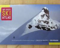
Off Piste Ski Atlas, Crested Butte Colorado ski touring and mountaineering. Click images to enlarge.
Any guidebook that begins with a Nietzsche quote and ends with a local mountain man’s poem is worth examining. In the case of the Off-Piste Atlas, the Teutonic philosopher who brought us “gott ist tot” weighs in with “For this is our height and our home…”
Whatever Nietzsche really meant by height and home (let’s just leave “gott tot” alone), it rings true for ski alpinists — and this Atlas does the job of providing the foundation for a study of CB backcountry highland philosophy.
Other “pamphleteers” promulgate these types of short, sweet and heavily illustrated guidebooks. This is one of the nicer ones. Full color oblique high-angle photos (many from aircraft) of the route areas are crisp, with good color balance. Each photo includes a useful compass rose, multiple numbered routes, brief access description, and meta such as summit elevation/loss. When necessary, the routes have brief descriptions. Snowmobile access info is there for the taking, and you get the exact starting point for your skin track.
Looking at this book from the point-of-view of a noob, I found two things lacking. First, exact GPS coords for trailheads and summits. Perhaps that’s not essential in a compact area such as that around Crested Butte, but in my travels I’ve found punching in the “gyp” for parking/trailheads to be super useful in avoiding confusion during early morning drives, sometimes in the dark. Likewise, it would be wise to provide value added with some route tracks available on the publisher website. Simple routes don’t need tracks, but skiers unfamiliar with gigantic ‘liths such as Mount Axtell could benefit from a pile of waypoints. Second thing: The overall coverage map is simply an aerial photograph with a few annotations. For the newcomer a nicely scaled topographic map would probably be more useful, seconded by a basic road map that gave a better idea of the overall driving layout.
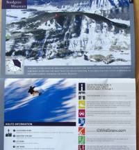
Some time ago this could have ended up as lift served; now it is skin served and delicious, garnished by the Off-Piste Ski Atlas
My perfectionist niggling aside, with perhaps a supplemental topo map for some areas in this 34 page book is all you’d need to do a full season or two of human powered glisse out of Crested Butte. After that, you might want to range farther but you’d also find yourself returning to discovered classics such as the controversial Snodgrass, historical Red Lady, and enigmatic Schuylkill. More, this is the kind of publication that helps you arrive cold as an out-of-towner, find the “skinners” and have at it while pounding fluffy Colorado pow and laughing at the over-priced ski lifts.
(Oh, and let me shout out the nice supplement of David Rothman’s poem on the closing pages. Rothman is a prolific writer/poet who works hard at interpreting the alpine sports experience as something more than basic me-and-Joe stories. Good to see his work get shared in this venue.)
Check out these guys’ website for this book as well as a Silverton, Colorado atlas. They’re probably planning on raiding WildSnow HQ next, in that case we’ll ask for a different opening quote to balance out Friedrich, how about:
…Around the glistening wonder bent
The blue walls of the firmament,
No cloud above, no earth below,
A universe of sky and snow!”
— John Greenleaf Whittier
WildSnow.com publisher emeritus and founder Lou (Louis Dawson) has a 50+ years career in climbing, backcountry skiing and ski mountaineering. He was the first person in history to ski down all 54 Colorado 14,000-foot peaks, has authored numerous books about about backcountry skiing, and has skied from the summit of Denali in Alaska, North America’s highest mountain.
13 comments
Great review! I personally feel that for routes described in this book, if you really need GPS coordinates, you probably shouldn’t be there in the first place. I love how recent improvements in gear and a wealth of info on the Internet & books has made backcountry accessible to more people. But I think there is a fine line to making it accessible & making it so accessible that people get themselves into trouble. How do others feel about this?
Hey Lou, any recommendations for Cascade, WA guidebooks? I was in awe of the Nelson BC resource you reviewed and this one looks pretty decent as well.
Reviews coming! Got quite a stack of new books here!
Funniest thing I ever saw was a well-known guide and guidebook author bitching about the crowded parking lot at a trailhead in front of clients.
We’re all human. But we are also funny!
Brittany,
That’s a debate I almost don’t want to touch (ha, but I will anyway 🙂 ).
My personal opinion is that we need to grow up. A guidebook is a service for the community, and the author should not have to lose a moments sleep about how others use that information–and certainly not have to worry about getting sued. If someone gets into trouble using it that is that individuals responsibility, not the authors.
I also get grumpy about the “locals only” mentality when it comes to guidebooks. I once heard about an Alaskan climbing guidebook’s author getting death threats because it gave away good climbing areas–and that’s just stupid.
Exercise is healthy, ski touring is fun, and the people who somehow feel their “raditude” threatened when someone else can do what they are doing need to grow up and analyze if they are doing it for themselves or to satisfy their own ego. Stop acting like a child and share the wealth. The world will be a better place for it.
Coats, good thoughts but I hope the “child” part was rehtorical rather than directed directly at Britt, please clarify just to prevent bad vibes. Thanks, Lou
Sorry Lou, my e-rant wasn’t directed at Brittany, or anyone else in particular. I am honestly sorry, Brittany, if you felt it was for a second. It was directed instead at the ego in all of us. I’ve been guilty of resenting people in “my” secret spots too, but ultimately I think it’s a selfish concept–trying to keep nature for ourselves.
Thanks, full speed ahead
I like a guidebook that doesn’t give it all away. To many GPS cords and such take some of the adventure out of exploring a new area. TH and summits are useful but multiple waypoints are too much in my opinion.
Lou, can we expect a review of Turiano’s new book?
Hi Aaron, eventually I’ll review every backcountry skiing related boot written, but I’ve got quite a backlog. Best to have too many than too few! Could actually use a few guest blog book reviews if anyone of the literary persuasion is interested. Lou
just another thought concerning making backcountry more accesible through guidebooks: Generally I´m with JC: I truely grant everbody who loves to be out there the informations ´bout where the best places for skiouring are, even the very “secret local infos”.
But on the other hand I´m happy that when I started backcountry skiing about 25 years ago there was NOT that huge amount of information available like today. Knowing everything in advancce takes a kind of qualitiy and adventure away. When I was young (now I´m 44) you first had to gain experience on “mainstream”-tours, and later you maybe saw an untracked coulouir or a distant peak and you had to try by yourself if it was accesible and if you could do it witout any information available in advance. That was kind of adventorous. Nowadays you find like almost everything in guidebooks or on the internet, at least here in Austria. That´s mainly fine but it also takes a quality of adventure away…
I have to agree with those who would do without the gps data. Of what value is a trip into the wild places if your hand is being held the whole way by a battery powered device and a set of step by step instructions. Too many now days are too reliant on purchased ‘knowledge’…where is the learning curve? Where is the sense of exploration?
I can proudly say that with the exception of perhaps the high arctic and its intricacies, you could place me anywhere on the planet with a paper map and I would be fine. This seems like a lost skill and I am only 37!
Don’t exit through the gift shop!
Comments are closed.