– The Backcountry Ski Touring Blog
  • Avalanches
  • Gear Reviews
    • Ski Reviews
    • Boot Reviews
    • Binding Reviews
    • Snowboard Splitboard
    • Book Reviews
    • Avalanche Beacon Reviews
    • Airbag Backpacks
    • Backcountry Electronics
    • Misc Gear Reviews
  • Podcast
  • Tips & Tricks
    • Ski Touring Basics
    • Boot Fitting
    • Fitness & Health
    • Gear Mods
  • Trip Reports
    • Fourteeners
    • Huts – Cabins – Lodges
    • Denali McKinley
    • 8,000 Meter Skiing
  • Stories
    • History
    • Humor
    • Land Use Issues
    • Evergreen Ski Touring
    • Poetry
  • Resources
    • All Posts Listed
    • 100 Recent Comments
    • Backcountry Skiing & Ski Touring Webcams
    • Ski Weights Comparison
    • Archives of WildSnow.com
    • Authors Page
    • Ski Touring Bindings
      • Trab TR2 Index and FAQ
      • Salomon Guardian & Tracker
      • Naxo Backcountry Skiing Bindings – Info Index
      • Silvretta Pure Backcountry Skiing Bindings – Info Index
      • Marker F10-12 Duke Baron
      • G3 Onyx Ski Binding FAQ
      • G3 ION Ski Touring Binding
      • Fritschi Backcountry Skiing Bindings – Info Index
      • Fritschi Diamir Frame Bindings Mount DIY
      • Fritschi Diamir Bindings FAQ
      • Fritschi Tecton FAQ
      • Atomic Salomon Backland MTN
      • Dynafit Tri-Step Binding 2001-2003
      • Naxo randonnee alpine touring AT ski binding FAQ
      • Dynafit Skiing Bindings – Info Index
      • Dynafit Binding Frequently Asked Questions FAQ
      • Dynafit Beast 16 FAQ Review 1
      • Dynafit Beast 16 FAQ Page Two
    • History
      • Ski Touring Binding Museum
      • Trooper Traverse Intro & Index
      • Randonnee Ski Touring “AT” ski gear — What is Hip?
      • Chronology
    • Backcountry Skiing Core Glossary
    • Gear Review Policy & Disclosures

– The Backcountry Ski Touring Blog

Banner
  • Avalanches
  • Gear Reviews
    • Ski Reviews
    • Boot Reviews
    • Binding Reviews
    • Snowboard Splitboard
    • Book Reviews
    • Avalanche Beacon Reviews
    • Airbag Backpacks
    • Backcountry Electronics
    • Misc Gear Reviews
  • Podcast
  • Tips & Tricks
    • Ski Touring Basics
    • Boot Fitting
    • Fitness & Health
    • Gear Mods
  • Trip Reports
    • Fourteeners
    • Huts – Cabins – Lodges
    • Denali McKinley
    • 8,000 Meter Skiing
  • Stories
    • History
    • Humor
    • Land Use Issues
    • Evergreen Ski Touring
    • Poetry
  • Resources
    • All Posts Listed
    • 100 Recent Comments
    • Backcountry Skiing & Ski Touring Webcams
    • Ski Weights Comparison
    • Archives of WildSnow.com
    • Authors Page
    • Ski Touring Bindings
      • Trab TR2 Index and FAQ
      • Salomon Guardian & Tracker
      • Naxo Backcountry Skiing Bindings – Info Index
      • Silvretta Pure Backcountry Skiing Bindings – Info Index
      • Marker F10-12 Duke Baron
      • G3 Onyx Ski Binding FAQ
      • G3 ION Ski Touring Binding
      • Fritschi Backcountry Skiing Bindings – Info Index
      • Fritschi Diamir Frame Bindings Mount DIY
      • Fritschi Diamir Bindings FAQ
      • Fritschi Tecton FAQ
      • Atomic Salomon Backland MTN
      • Dynafit Tri-Step Binding 2001-2003
      • Naxo randonnee alpine touring AT ski binding FAQ
      • Dynafit Skiing Bindings – Info Index
      • Dynafit Binding Frequently Asked Questions FAQ
      • Dynafit Beast 16 FAQ Review 1
      • Dynafit Beast 16 FAQ Page Two
    • History
      • Ski Touring Binding Museum
      • Trooper Traverse Intro & Index
      • Randonnee Ski Touring “AT” ski gear — What is Hip?
      • Chronology
    • Backcountry Skiing Core Glossary
    • Gear Review Policy & Disclosures
   

Rogers Pass North Guidebook — Part 2, KML and Google Earth

by Lee Lau February 20, 2014
written by Lee Lau February 20, 2014

Please see Part 1 of this review.

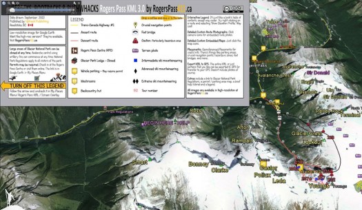
KML map legend overlay

KML map legend overlay

Part 1 of this review dealt with an uncontroversial topic — a guide to a ski touring/ ski mountaineering region in e-book PDF format. Part 2 assesses Rogers Pass North as a constantly improving, iterative content bundle of information delivered in a KML file closely integrated and layered in Google Earth. The KML file is freely available here.

Be warned that if you start looking at this it is a MASSIVE TIME SINK especially if, like me, you are a fan of big mountains, huge glaciated terrain and Google Earth. Some of the guidebook content integrated with KML/Google Earth functionality that Rogers Pass North includes:

– Topo – route map overlay
– Terrain photos with routes embedded as clickable pictures
– Satellite terrain as a layer
– Parking, facilities, and access point locations
– Services finder
– Embedded map legend

Moreover, this allows you to import your GPS information and integrate it with Google Earth. This requires another third party app and is frankly something I’ve not delved into. Read more about it here.

In most circumstances, this functionality would have limited use as Google Earth’s full suite of services and terrain detail requires Internet or mobile data access. However, much of the terrain at Rogers Pass within the day tour purview is serviced by cell towers and has high-speed internet connectivity. If you have a TELUS phone you’re in luck and you can play with Google Earth and the guidebook KML as you chill on a peak preparing to descend thousands of meters of pow. Otherwise watch your roaming bill or geek out on mountains in the comfort of where ever you’ve poached a connection.

After you download the KML file from geobackcountry you get the standard Google Earth view of Rogers Pass. Mountain names are in my version of GE only because I’ve downloaded the BC.kmz placenames file from this site.
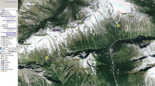
Open up your GE sidebar and you can select what map information layers you want to appear. In this I've unchecked the Geobackcountry map legend and checked off the "Maps" function

Open up your GE sidebar and you can select what map information layers you want to appear. In this I've unchecked the Geobackcountry map legend and checked off the "Maps" function.
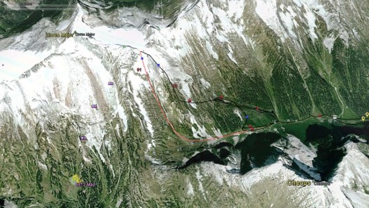
This is what the 8812 Bowl section of the Connaught Creek drainage looks like with all of Geobackcountry's layers enabled. There's a wealth of information including "Maps" and "Terrain Photos" for example

This is what the 8812 Bowl section of the Connaught Creek drainage looks like with all of Geobackcountry's layers enabled. There's a wealth of information including "Maps" and "Terrain Photos" for example.
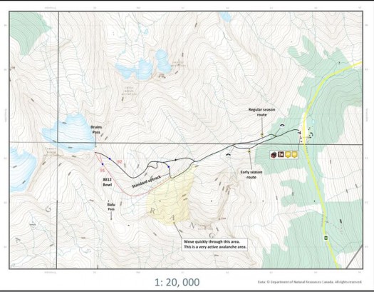
Clicking on the 8812 map legend in GE brings up a pop-up window with this map of 8812 Bowl. It should look familiar as it's straight out of the guidebook. This function is seamlessly integrated into Geobackcountry Rogers Pass KML file.
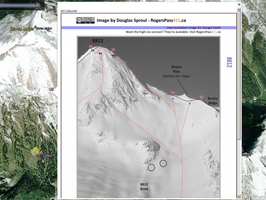
Clicking on the 8812 map legend in GE brings up a pop-up window with this map of 8812 Bowl. It should look familiar as it's straight out of the guidebook. This function is seamlessly integrated into Geobackcountry Rogers Pass KML file.

Clicking on one of the photo icons in GE then brings up terrain photos from the guidebook; again this is seamlessly integrated into the KML file

Clicking on one of the photo icons in GE then brings up terrain photos from the guidebook; again this is seamlessly integrated into the KML file.

Google Earth is all very well while you’re researching trips or looking at things in the comfort of home on a large screen in comfortable temps or in range of a cell tower. Obviously unusable without internet connectivity GE has limitations and that is where the mobile feature of Rogers Pass North comes in handy.

Basically for $30 the guidebook is provided in mobile format
i.e. the same content from the PDF guide but broken down into folders which can then be viewed on a mobile phone. The folders are arranged by geography in the convention used by the author. The mobile guide can be viewed on an IOS or Android phone and viewed on said phone thus obviating the need for an always-on connection as a local copy of the information required is present on your mobile device.

Downloading the mobile guidebook directly to an Android phone is easy. Simply follow the instructions here. The download itself is big (the 1st edition of Rogers Pass North is 333MB so make sure you have a fast connection on an internet hotspot so you don’t blow through your cell data plan. Downloaded output is as a ZIP file thus preserving folder structure.

If you choose to download to computer first, the process of then getting the content to the phone is pretty simple but not without quirks. First I got my computer to recognize the phone as a drive (it’s a LG G2 and I understand with Samsung phones its is even easier). Instead of using the native LG PC Suite application as a file manager I uploaded the entire “Rogers Pass” folder to the top layer directory of my Android phone ie at the same level as “Music”, “Amazon” etc.

(Editor’s note: Be very careful hooking your Android smartphone up to your computer for the first time. If you’re used to the process, fine, but sometimes your phone will be loaded with grenades in the form of adware and malware waiting patiently for that first time connection to your PC. A safer method is to purchase a pigtail SD card reader for your phone, place the files from the computer on an SD card, and go that route.)

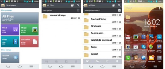
Now that the mobile guidebook is on my phone here are the steps to get it to show where I want. My phone has a “File Manager” in the Apps. To find the “Rogers Pass” directory then place it on your home page I used the steps below. Alternatively to make your life easier, one can download the link directly to phone by following the steps outlined in the Geobackcountry link specific to Android phones

This is where it gets interesting and where I frankly haven’t made my mind up. Doug Sproul has some interesting thoughts on the future of guidebooks and is free with ruminations on GeoBackcountry’s FaceBook page. He’s an old school paper map guy but obviously more willing to be open minded than most and thinks that we are possibly at the stage where we can dispense with maps and just use a phone for navigation. I don’t think that’s a practical reality as yet (phones can die, batteries run out, glare from bright light) and other’s share this caution for other reasons (people are used to viewing maps in large format, ease of use etc) but it’s an interesting and perhaps, controversial topic.

Android screen shots.

Android screen shots.

1. Open the “File Manager” app. If you don’t have “File Manager” download it so you can manage files as folders. Click on the “All Files” grey tile
2. “Internal Storage” then appears (intuitive names huh?). Click on that.
3. Scroll through the mess of files and locate “Rogers Pass”
4. Press down on the “Rogers Pass” folder until a drop down menu appears. Move that folder to wherever you want; in my case I selected my phone’s home screen.
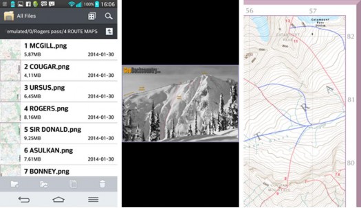
Navigation through the folders is like a PC desktop. You can bring up mountain terrain shots or maps.

Navigation through the folders is like a PC desktop. You can bring up mountain terrain shots or maps.

Doug is an old-school hippie. He believes that knowledge is power. That ethos is in his guidebook. Frankly for the amount of information presented Rogers Pass North is underpriced but Doug doesn’t want to hear anything about it. He wants people to read the guide, dive in and enjoy the immersion. He knows Rogers Pass North doesn’t lend itself to casual browsing but then the guidebook is complex because Rogers Pass is complex and mountains are complex.

It is not just an invaluable and definitive guide to Rogers Pass, it is also a work of art–so much so that I’ve ordered a print copy for myself.

If you want to get your hands on a copy (and anyone who loves mountains should at least look at the free KML file and blow your mind); head over to the Geobackcountry site and get your virtual paws on the guidebook for $25 or the mobile version for $30.

Please see Part One of this review.

Lee Lau

Guest blogger Lee Lau is an avid skier and outdoorsman embarking on many adventures with his loving, and sometimes concerned wife, Sharon. He has over 15 years of experience skiing, ski-touring and dabbles in mountaineering. In the “off-season” he is occasionally found working in his day job as an intellectual property lawyer when he is not mountain biking. As a resident of Vancouver, British Columbia, Lee’s playground extends mainly to Western Canada, including South West B.C. and the Selkirks.

www.leelau.net/sharonandlee/
22 comments
0
FacebookTwitterPinterestEmail
previous post
Rogers Pass North Guidebook — Part 1
next post
B&D Ultimate Cuff Pivot –Ultra Light (UCP-UL)

22 comments

Jack February 20, 2014 - 12:18 pm

Mind blowing. This guidebook/KML integration just seems like it has brought backcountry guides forward several decades in time. Three cheers!

The electronic chart / paper chart dilemma exists for boating, as well. IMNSHO, a nice, waterproof, tear resistant chart as backup is very welcome insurance.

Lou Dawson February 20, 2014 - 12:31 pm

I’m thinking this whole thing is worthy of some kind of award, perhaps top prize at Banff book festival for the guidebook category? I won that once, with something that seems like stone age cave painting compared to this!

Lee Lau February 20, 2014 - 9:18 pm

The video will blow your mind

https://vimeo.com/75838426

Douglas Sproul February 21, 2014 - 6:33 pm

Lou,
Thank you. Very honoured when I read your comment. Your work hugely inspired me to create GeoBackcountry. Being that I created this work during an age of a higher level of technology, it may appear really advanced and all but the way I see it is that it’s the experience that we share with others that people will benefit from and always remember.

Your works are masterpieces and are far from stone age sir. They have helped people for many years, and surely, many more to come. I have two very well worn Colorado’s Fourteeners books to prove that. Hope to make it back there someday and put them back into use! -Douglas

Aaron Trowbridge February 22, 2014 - 8:16 pm

Thanks for the review Lee, can you clarify for me if the kml product is a subset of the ebook and mobile version? Seems like a bunch missing from the kml.

Amazing product! I’ve always wanted guidebooks to move digital. GoogleEarth is such a powerful tool for pre planning. Kudos too for using 1:20 000 trim data, the 20m dem really pops out more subtle terrain features. I’ve made a bunch of my own ski maps using it over the yrs and it really helps with meso scale route planning.

Lou Dawson February 23, 2014 - 7:17 am

Map experts please correct me if I’m wrong, but no 20 meter DEM available for the U.S., only 40 meter? I’ve been using the 40 meter to build maps for years, see hutski.com and backcountryskiingco.com but it results in maps with only general contour lines. Lou

Coz February 23, 2014 - 7:22 am

Someone just introduced me to hillmap.com. Just an awesome tool for route planning. Check out the slope overlay – a great initial tool for assessing avy risk during route planning.

Douglas Sproul February 23, 2014 - 9:05 am

Aaron, The KML is a subset component to GeoBackcountry Mobile Optimized Guide and it is designed to work with the guide. It contains route lines for ascent and descent of the 100 ski routes and variations of GeoBackcountry. Route numbers (from GeoBackcountry Guide) show when zoomed in to the highest level.

I intentionally designed the KML to be as clean as possible for easy reading. It also contains waypoints of parking areas, foot bridges and trail junctions. I offer what I call the Fresh Pow Program which is free updates for three years from purchase. The point of that is as time goes on and I receive feedback, I will make changes and update the file. Anyone who was purchased it will get a free update.

Since this is the first of it’s kind, I am hoping that other people will see the potential and offer their feedback, suggestions, corrections and advice and together, we’ll make it even better. It’s an adventure and you’re all invited.

Lou, I have been searching for 1:20,000 for The States and I haven’t been able to find anything. I’ll dig a little deeper. Nice work with the hutski.

Coz, Hillmap is neat. Thanks for pointing that out!

Aaron Trowbridge February 23, 2014 - 9:58 am

Slope maps with colour ramp divisions tied to critical avy slope angles can be very useful for route finding. With the 20m dem lower angle ramps pop out nicely.

Aaron Trowbridge February 23, 2014 - 3:06 pm

Thanks Doug, does the guide include sapphire col and asulkan glacier? I’m not seeing those areas on the kml which I’ve only viewed on an android phone.

Stellar product, thanks for taking the risk and innovating!

Lee Lau February 24, 2014 - 6:09 pm

Aaron that’s for Rogers Pass South! It’s in the Geobackcountry mobile download in part 2

Douglas Sproul February 25, 2014 - 11:40 am

Aaron, Yes, GeoBackcountry Rogers Pass includes Sapphire Col and Asulkan Glacier. If you are referring to the free KML that I have on the website, there are only three areas included in that. GeoBackcountry Rogers Pass has 100 day tours with variations around Rogers Pass. Thanks.

Luddite February 25, 2014 - 3:25 pm

So much for adventure! My last tour at Rogers we wandered up to an area I knew nothing about but had seen from afar. It was awesome! For me it would have not been the same if I’d studied the area on Google Earth prior and known what was beyond each ridge. We spent our times looking at the mountains not at a phone. Soon you’ll be able to use your google glasses to find your way through the mountains with a voice and arrows telling you when to alter your path. We’re turning our premiere wilderness/backcountry into lift-less ski areas.

Lee Lau February 25, 2014 - 3:41 pm

It’s never a good review article without a back -in-the-good-old-days rant

Lou Dawson February 25, 2014 - 4:47 pm

As an Elmer, I’d agree. Am always tempted, but try to avoid succumbing unless I can be amusing, sort of as a museum display. Lou

Joel February 26, 2014 - 3:25 am

Lee Lau: that last comment is very not constructive. If you don’t want comments, turn them off for your post maybe?

Luddite has valid points. What does it sound like when you put together a paper trail map, a smartphone/gps app, and talks of a hotel/hostel resort? To me this is straying away from backcountry.

Doug: I admire your pioneer spirit. Your adventure is an incredible one to live.

My first thoughts when I heard of rogerspass411 was; is this a good thing?

I appreciated going through the classic roger’s pass guidebook and the more I skied, the more I looked across to other ridges, runs, lines, across valleys. Then comes the good stability days combined with the right friend(s) and a new adventure that we’ve been wondering about.

Maybe the new guidebook will improve the ski touring experience? Maybe it will take the adventure out of it for the reader. Time will tell.

I guess as of now you can use the book and ski north, or pick your own way south.

I personally won’t buy the book. There are so many places to go check out on an always changing wish list in my head. But I am sure I will see someone every single day out using the book. Most of my friends will probably buy it. I’ll end up ”using” it whether I chose it or not… Over time I’ll make an opinion.

Now for the rant…

One thing is for sure, there are way too many red platers these days so getting in good shape and faster is key to finding ”backcountry”. The hotel getting shut down might be a good thing otherwise it’d be worse! The prices at that hotel were pretty affordable, about the same as Wheeler hut (or is it that one that’s overpriced). I also wish Parks put some pants on and tell CP to f— off. A private company controlling a government institution, I guess that’s not news.

Lou Dawson February 26, 2014 - 7:47 am

Correct me if I’m wrong, but are there not several guidebooks prior to this with plenty of Rogers Pass information?

As for sharing information about a cool place, sure, I think keeping things secret or more challenging is a legitimate “goal” if that’s your persuasion and opinion. Yet doing so is quixotic.

Keep in mind that there is a long list of reasons why sharing backcountry skiing route information is a good thing, and those reasons will keep guidebooks happening. Thus, the guidebook will be sitting there, available, while those who don’t like the book attempt to keep a place secret. That’s nonsensical — quixotic.

Might be best to just look at the positive aspects of guidebooks. One of the best things is they help spread out use. They also help increase safety by giving people from other places solid information that would otherwise only be known by locals. Guidebooks are also nice in their own right, as many people who don’t get out much use them as dream books.

Another positive aspect of guidebooks is they “legitimize” things, which can help when you need to involve the government or non-profits in things like parking improvements, rescue resources, etc.

Me, in coming from a climbing as well as ski mountaineering background, I’ve never had any problem with guidebooks. I’ve always liked them, and enjoyed making a few contributions myself. In terms of increasing use, I wish my books did have that kind of power, but they don’t. In reality guidebooks are just support for existing recreational trends, they don’t cause those trends.

Stewart February 26, 2014 - 8:37 am

Rogers Pass provides easy access to incredible terrain and snow, so has become deservedly popular. Sure I look back fondly on the years before the crowds, the fees, the maps and guidebooks, when it felt like we were exploring, but with a little time and effort those same experiences can be found just about anywhere else in these parts. This new guidebook is certainly impressive, and must have been a joy to create. My only concern is the idealism of including the boldest of lines. I suggest they could be a dangerous temptation to people who lack experience with individual responsibility in high consequence situations.

Lee Lau February 26, 2014 - 9:20 pm

Joel – I bit my tongue when I read Luddites’s post. His post was ludicrous. Your interpretation of his post is generous.

Allow me to expand.

Luddite said:

“So much for adventure! My last tour at Rogers we wandered up to an area I knew nothing about but had seen from afar. It was awesome! For me it would have not been the same if I’d studied the area on Google Earth prior and known what was beyond each ridge. We spent our times looking at the mountains not at a phone. Soon you’ll be able to use your google glasses to find your way through the mountains with a voice and arrows telling you when to alter your path. We’re turning our premiere wilderness/backcountry into lift-less ski areas.”

Taken at face value Luddite is fine with not knowing what is “beyond each ridge”. If you take what he says literally even looking at a map demeans the experience. For every Luddite there are people who are happy to look at maps, Google Earth, weather patterns, aerial shots to try to plan routes, to find new areas, to figure out how to navigate new terrain.

Now Joel as to your point and I emphasize this is for discussion:

“Luddite has valid points. What does it sound like when you put together a paper trail map, a smartphone/gps app, and talks of a hotel/hostel resort? To me this is straying away from backcountry.”

There has been maps of this area for a long long time (ie the 1:50,000s). Are you suggesting saying that having maps of an area makes it not backcountry?

There is talk here of a hotel in the same vein as the old Glacier Park Lodge/Best Western but smaller. Are you also suggesting that having a hotel here makes it not backcountry?

It seems to me that the smartphone/gps app is an improved way of navigation. Are you suggesting that having improved navigation of an area means that is not backcountry

Don’t even get me started on how Parks Canada kowtows to CP

Lee Lau February 26, 2014 - 9:21 pm

Aye Stewart – I was a bit taken aback when I saw the lines Doug put in the book. It’ll be interesting

Lee Lau October 27, 2014 - 4:19 pm

What a surprise. I look back and Joel and Luddite have nothing to say in response.

Kickstarter for the new 2nd edition print version!

https://www.kickstarter.com/projects/geobackcountry/geobackcountry-rogers-pass-backcountry-skiing-guid

Lou Dawson 2 October 27, 2014 - 5:56 pm

Lee, thanks for dropping by! We missed you.

Comments are closed.

Recent Comments

  • Brian Oney on The “New Math” for Sheltering from the Storm
  • Tuck on Low Tech Safety with the Snow Visa
  • Steve G. on Light and Fast or Fun and Functional? The Eternal Decision
  • TeleNinja on Small Scale Water Filtering with LifeStraw’s Peak Squeeze and Peak Straw
  • Nick on Small Scale Water Filtering with LifeStraw’s Peak Squeeze and Peak Straw

Gear Reviews

  • Phantom Slipper and Slipper HD – TESTED

    May 26, 2022
  • Revisiting the Blue Ice Harfang Crampon

    May 24, 2022
  • Patagonia Micro Puff Storm Jacket

    May 19, 2022

Trip Reports

  • Mount Sanford from the Road

    May 9, 2022
  • Techniques and considerations for ski mountaineering on glaciers

    February 16, 2022
  • Making the Most out of the Alaska Range

    February 14, 2022

Totally Deep Podcast

  • Totally Deep Podcast 99: Big Geography with Roman Dial and Alex Lee

    April 20, 2022
  • TOTALLY DEEP PODCAST 98: Live at the EMGT with Cam Smith

    April 12, 2022
  • TOTALLY DEEP PODCAST 97: Talk of Gear for Next Year

    March 23, 2022

Tips & Tricks

  • A Shoulder Season Ski Traverse: Three People, Three Sleep Systems

    May 27, 2022
  • Springtime Primer: Securing Skis/Splitboard to a Bike Frame

    May 16, 2022
  • Fueling For Ski Touring

    May 3, 2022

Ski Touring Stories

  • Stumbling through Sagebrush and into the Danger Zone on Steens Mountain

    May 31, 2022
  • Update: Bighorn Sheep and Backcountry Skiers/Riders in the Tetons

    April 26, 2022
  • Backscratchers in My Brain

    April 6, 2022

Newsletter Sign-Up

  • Facebook
  • Twitter
  • Instagram
  • About Lou Dawson
  • Authors Page
  • About
  • Contact
  • Copyright & Legal
  • Website Security

@2020 - All Rights Reserved. Designed and Developed by WildSnow


Back To Top

Read alsox

Low Tech Safety with the Snow...

June 24, 2022

Norrøna Lyngen Gore-Tex Pro Pants Review

June 22, 2022

Small Scale Water Filtering with LifeStraw’s...

June 20, 2022